Old Photographs 2

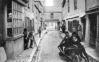
Tamar Street around 1900
Looking along Tamar Street from the southern end towards the Passage House Inn, there is a group of three boys with a wooden wheelbarrow in the foreground of this photograph. On the narrow cobbled pavement to the left, behind the bay window of a shop, an artist sits on a low stool with his easel in front of him. The buildings fronting on the narrow street are varied in appearance, with some being whitewashed, others bare brick, and at least one slate-fronted. At the far end, the upper storey of the Inn pas
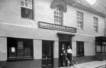
The Green Dragon Hotel, in Fore Street
This angled shot shows the whole front of the two-storey Green Dragon Hotel, the old coaching inn which formerly stood on Fore Street where the Co-op store now is. Four small-paned sash windows run across the upper frontage, with a large picture window, two doorways, and another small window below. The proprietor is posed for the camera in the porticoed main entrance, with his wife, his son, and his dog, while a guest watches the photographer from an open first-floor window to the left of the picture.
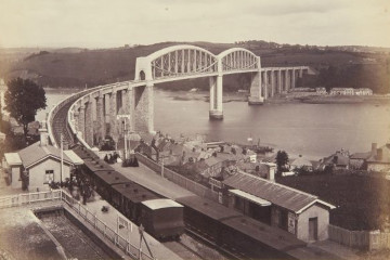
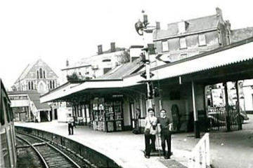
The station in the early 1900s
In this photograph there is a train with three or four carriages and a guard's van stopped, facing Plymouth, in front of the small station building to the left. The waiting room on the other side of the tracks is in the right foreground, with the buildings and rooftops of the lower part of Saltash visible behind and beyond it.  The track curves around to the right, displaying the whole length of the Royal Albert Bridge with the waters of the Tamar below running across the middle of the scene. The St Budeau
The station in the mid 1900s
This photograph, probably taken from a window of a west-bound train, is focussed on the 'new' main station building, with flat roof extensions over part of the platform and, supported on pillars, above the main access to it. Through the pillared opening on the right a car can be seen parked on the street outside the station. Two young men are standing facing the camera side-by-side on the platform, one of them leaning against the signal pole in the centre of the picture. In the middle ground to the left a
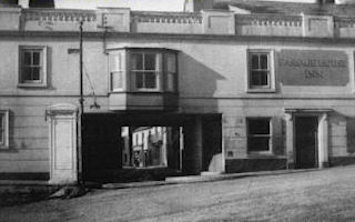
The old Passage House Inn
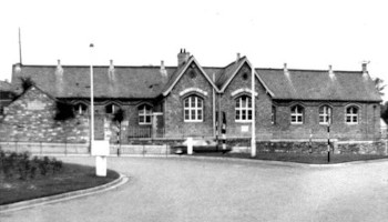
This close-up photograph shows most of the front of the old Passage House Inn, with its second storey passing over the end of Tamar Street. Part of Tamar Street can be seen through the opening, which has a bay window above it. A doorway opens into the Tamar Street to the right, underneath the arch, and there is another door in the right frontage, flanked on each side by a window. Above this door, between another pair of windows, the name of the Inn is painted. The whole front wall of the building is surmou
North Road School
This close-up photograph of North Road School, taken from the approach road after the Tamar Bridge was built, has in the left foreground part of the roundabout and in front of the school to the right the grassed traffic island which were part of the new junction between the Brige, North Road, and Fore Street. The single-storey school building has a double gable end extending outward slightly from the centre of the long side, with a six-paned window in each gable end and four four-paned windows evenly space
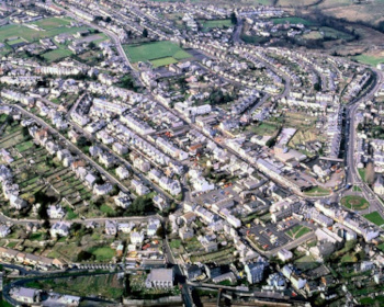
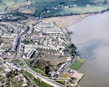
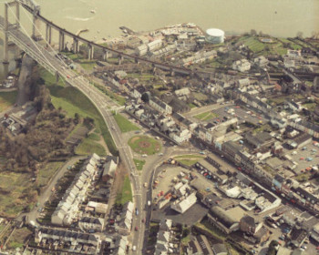
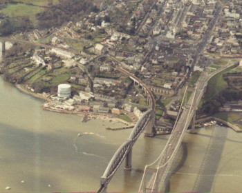
Aerial photos taken in 1981/1982
This aerial photograph looks more-or-less north-west over Saltash town centre. Warfelton Field, Longstone Park, and the junction of Fore Street with Callington Road and St Stephens Road are in the top left quarter of the picture, with Fore Street running diagonally down to the right. North Road runs up the right-hand side of the picture, with the Co-op car park, Alexandra Square, and the bridge approach roundabout in the bottom right quarter. This aerial photograph, taken at high tide, looks more-or-less north-west over the area between and around North Road and Old Ferry Road. The foreground shows the bridge approach roundabout, Elwell Woods, a large area of allotments, the end of the Tamar Bridge, a grass-covered Jubilee Green, and Brunel Green. In the background, behind the massed rooftops of houses in a built-up area, are the triangular area of reclaimed land which will become Saltmill Park, and the farm fields and scattered houses of MiddlTavy Road and Elwell Road are in the left foreground of this aerial photograph, taken looking more-or-less south-east over the eastern end of Saltash. To the right of them are the ends of North Road and Fore Street, with the old North Road School and Working Mens Club buildings prominent between them, and the Co-op car park at the far right. The middle ground of the picture shows Elwell Woods, the bridge approach roundabout, the top end of Lower Fore Street, Alexandra Square, and part of Albert Road. BehinTaken looking almost due west from above the Royal Albert Bridge and the Tamar Bridge, this aerial photograph has the main spans of both bridges in the foreground with the waters of the Tamar below. the whole of the south-eastern 'corner' of the town is visible from the Coombe valley on the left to the end of North Road on the right, and from Waterside up to the top of Fore Street.

^ to top ^

page updated 2025-03-21